 |
 |
|
 |
 |
Geographical Location |
 |
|
 Alian District is located on the northeast side of the Kaohsiung Plain at east longitude 120.1923/north latitude22.5303. It is situated on the north end of the western territory of Kaohsiung City, in between Erren River and Agongdian River. It borders Dagang Mountain and Tianliao District to the east, in the west with Lujhu District, in the north with Erren River and Guanmiao District of Tainan City and Gueiren District, and in the south with Gangshan District. Alian District is located on the northeast side of the Kaohsiung Plain at east longitude 120.1923/north latitude22.5303. It is situated on the north end of the western territory of Kaohsiung City, in between Erren River and Agongdian River. It borders Dagang Mountain and Tianliao District to the east, in the west with Lujhu District, in the north with Erren River and Guanmiao District of Tainan City and Gueiren District, and in the south with Gangshan District. |
|
Climate and Hydrology |
|
|
Alian District is located on the southwest side of Taiwan, south of the Tropic of Cancer. It belongs in the tropical climate region, with cool, dry winter and rainy, hot summer weather. Spring and autumn is relatively short. Since Taiwan is situated on the contact zone of the Asia Continent and the Pacific. The climate is significantly influenced by the seasonal wind.
The southwesterly seasonal wind blows in the summer from early May to late September, for a total of four months. However, the large volume of moisture brought about by the wind makes southern Taiwan and southwestern Taiwan prone to rain; this is the important rainy season of the year. In the winter, the northeasterly wind blows and brings the rainy season to the northeastern and northern part of Taiwan. Alian, situated in the southwestern region, does not benefit from the rain and experiences drought often.
Although Alian is located in Kaohsiung City, it is closer to the Tainan weather observation station than it is to the Kaohsiung observation station, hence readings from both stations are taken into consideration here for comparison. Alian has an annual average temperature of 25 degrees, with great temperature differences throughout the year; in the summer it can reach as high as 36 degrees, while the coldest temperature for winter is 7 degrees, a difference of 29 degrees. The annual rainfall is approximately 1670mm (aggregate between Tainan and Kaohsiung), this is relatively high, although the rainfall is concentrated between April and September, with little to no rain during the other months. From the rainfall distribution point of view, the rainy days are few and unevenly distributed, especially with the approach of the typhoon season, as much as 300mm of rain can be accumulated in one day.
|
|
Mountains and Rivers |
|
|
 |
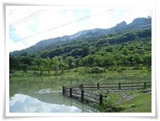
Dagang Mountain |
| |
 Dagang Mountain is a plateau shaped square mountain arising out of the plain; it is the only place with higher altitude in Alian District. Dagang Mountain is roughly 4km long from north to south and 7km wide from east to west. The southwestern region has an altitude of 312m, while the plateau surface on the top of the mountain slants 8 degrees gradually from the west to the east. The western side of the mountain is a vertical cliff roughly 30~50m tall, which extends from the south to the north. The eastern side of the mountain is also a 30m tall limestone cliff, with protruding limestone beneath the cliff. Dagang Mountain is a plateau shaped square mountain arising out of the plain; it is the only place with higher altitude in Alian District. Dagang Mountain is roughly 4km long from north to south and 7km wide from east to west. The southwestern region has an altitude of 312m, while the plateau surface on the top of the mountain slants 8 degrees gradually from the west to the east. The western side of the mountain is a vertical cliff roughly 30~50m tall, which extends from the south to the north. The eastern side of the mountain is also a 30m tall limestone cliff, with protruding limestone beneath the cliff.
Dagang Mountain consists of bulging coral lime, it is one of the very few places in Taiwan featuring such terrain. Since limestone is loose in structure and porous, rainwater seeps easily downwards, hence there is virtually no river formation on the surface. Due to the erosion effect of the coral lime on the earth’s surface, there are many troughs and depressions on the surface, making it difficult to walk on. Sometimes a large, narrow yet long rock trench is formed, such as the single line sky terrain, and sometimes it forms the slight indentations called Doline, or limestone hills; the entire terrain surface is not very flat. |
|
Erren River |
| |
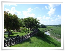 Erren River was called Ercengsing River, and in 1960 it was renamed Erren River by the Taiwan Provincial Government; it originates from the Shanjhu Lake in Mujha Village of Neimen Township in Kaohsiung County. It is the river that borders Kaohsiung County, Tainan County and Tainan City, which flows through townships such as Neimen, Tianliao, Alian Hunei and Cieding in Kaohsiung County as we as Longci, Guanmiao, Gueiren and Rende in Tainan City. It flows into the Taiwan Straits near Baishalun of Cieding Township, the total length is 62.2km and the average gradient is 1:142. It is one of the more gently sloping rivers in Taiwan. Erren River was called Ercengsing River, and in 1960 it was renamed Erren River by the Taiwan Provincial Government; it originates from the Shanjhu Lake in Mujha Village of Neimen Township in Kaohsiung County. It is the river that borders Kaohsiung County, Tainan County and Tainan City, which flows through townships such as Neimen, Tianliao, Alian Hunei and Cieding in Kaohsiung County as we as Longci, Guanmiao, Gueiren and Rende in Tainan City. It flows into the Taiwan Straits near Baishalun of Cieding Township, the total length is 62.2km and the average gradient is 1:142. It is one of the more gently sloping rivers in Taiwan.
Erren River is a main river in southern Taiwan. The pristine ecological conditions along the bank attract many bird species and bird nests. The schools of fish frolic next to the water plantation, while flora and fauna all flourish here.
|
|
|
 |
 |
 |
|